
Choose one part of the city before you choose the stops. A beach, a museum and a wildlife park can all look close on a zoomed-out map, but the journey between them can consume a child's afternoon. This guide pairs a location map with a list that works without map tiles or a mouse.
| Plan first | Useful answer |
|---|---|
| Coverage | Perth, Fremantle, Mandurah and nearby day-trip areas |
| Best first step | Filter by area, then check the operator's current opening and booking details |
| Costs | The map includes both free sites and paid attractions; individual guides explain the difference |
| Transport | Check Transperth's journey planner or the venue before leaving |
Family destinations by area
Each dot links to the matching named destination below. This coordinate plot shows relative positions, not street routes or a precise entrance. Open “Street map” for detailed paths and directions.
Recorded place coordinates from OpenStreetMap contributors, ODbL. Park, beach and lake area points do not mark entrances. Map data attribution and licence. Checked 25 September 2026.
- Rio Tinto Naturescape Perth. Playground site.Family guideOfficial visitor informationStreet map
- Scitech Perth. Museum building.Family guideOfficial visitor informationStreet map
- Scarborough Beach North coast. Beach area.Family guideOfficial visitor informationStreet map
- Wembley Golf North coast. Golf-course area; mini golf entrance may differ.Family guideOfficial visitor informationStreet map
- Whiteman Park Swan Valley. Park area; use official entrance directions.Family guideOfficial visitor informationStreet map
- Swan Valley Visitor Centre Swan Valley. Visitor centre building.Family guideOfficial visitor informationStreet map
- Lesmurdie Falls National Park Perth Hills. Park area; choose a trailhead separately.Family guideOfficial visitor informationStreet map
- Lake Leschenaultia Perth Hills. Lake area; not an entrance or swimming point.Family guideOfficial visitor informationStreet map
- South Beach Fremantle. Beach area; service-station result rejected.Family guideOfficial visitor informationStreet map
- Coogee Beach Fremantle. Broad beach area; check barrier location separately.Family guideOfficial visitor informationStreet map
- Adventure World South. Theme-park grounds.Family guideOfficial visitor informationStreet map
- Perth's Outback Splash North coast. Theme-park grounds.Family guideOfficial visitor informationStreet map
- Perth Aqua Park South. Water-park area; reopening 17 October 2026.Family guideOfficial visitor informationStreet map
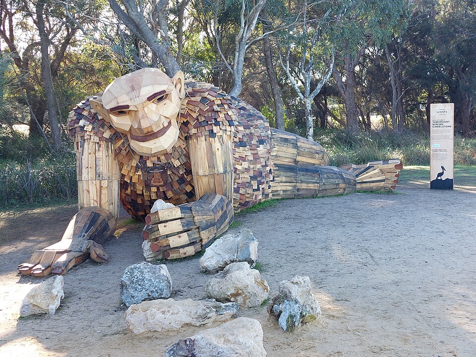
- Mandurah Visitor Centre Mandurah. Get current Giants route here; not a sculpture pin.Family guideOfficial visitor informationStreet map

Use the map as a starting point
Pins are coordinates of named places recorded in OpenStreetMap, with the place type checked against the destination. They are not a live confirmation of admission, car-park availability or an accessible entrance. The list below the map has the same destinations as links, including an official venue link for each one. If the map does not load, use the list. A broad lake or reserve pin marks the place, not the exact swimming or trail entrance.
For a short outing, choose a Perth stop such as Rio Tinto Naturescape or Scitech. For a longer day, look at Lake Leschenaultia or the Mandurah Giants. Group stops by area using our family day trips guide.
Match the outing to the day
For free entry, begin with Naturescape, a park stop at Whiteman Park, or the Mandurah Giants. A visit can still involve parking, transport, food or optional paid activities. WA Shipwrecks Museum has free general admission, while Scitech, Adventure World and Perth's Outback Splash require tickets. Check age and supervision rules at water venues before promising a particular ride.
Seasonal attractions need an extra check. Adventure World and Outback Splash list 26 September 2026 as their new season start; Perth Aqua Park lists 17 October 2026. Their opening days still vary. See theme parks and water parks for a useful comparison.
Before you set off
Open the official link from the map list, check that day's hours and conditions, then navigate to the listed entrance or visitor centre. For the beach, read the coastal forecast and swim between flags where patrols operate. For bushland and lakes, check fire and water notices. The map data is a planning aid dated 25 September 2026, not a real-time status feed.